FOR INFORMATION, VISIT THE GEORGIA WATERFALL MAP BY Mark Oleg Ozboyd
Upper Falls
The four falls on Fall Creek are in the Wildcat Tract of Dawson Forest. The highest part of the trails in the Wildcat Tract is the beginning of the Tobacco Pouch Trail, accessed from Monument Road. The lowest part of the trail is the Wildcat Campground on the Amicalola River. The total elevation change is almost 1400 feet. From Monument Road, follow the Tobacco Pouch Trail for 0.3 miles to the junction with Rocky Ford Trail at the sign. Turn left onto the Fall Creek Trail and go downhill for about .6 miles to Fall Creek. Follow the creek downstream for about .3 miles to the creek crossing. The first falls will be on the right soon after crossing the creek and is a continuous cascade for several hundred feet. It is difficult to get close to because of the thick undergrowth.
Upper Falls coordinates: 34.513,-84.32366
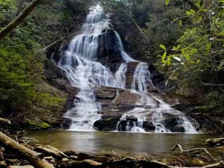
Lower Falls
Travel another 0.7 miles of down and up hiking before reaching the cove below the second and largest falls on Fall Creek. Walk up the cove a short distance on fairly level ground to this impressive falls. Fall Creek Falls coordinates: 4.5156,-84.3185Continue to follow the trail downstream about 0.7 miles where the trail crosses over the creek once more. The third falls will be on the left. Continue on the trail to the cove and walk up the cove a short distance on level ground to view the falls.
Lower Falls coordinates: 34.51316,-84.30716
Fourth Falls
Continue to follow the trail downstream about 0.7 miles where the trail crosses over the creek once more. The third falls will be on the left. Continue on the trail to the cove and walk up the cove a short distance on level ground to view the falls. Lower Falls coordinates: 34.51316,-84.30716 Rejoin the trail at the bottom of the cove. Continue on Fall Creek Trail past the junction with Tobacco Pouch Trail to the junction with Wildcat Trail. Just before reaching Wildcat Creek is a trail to the left. This trail leads about .5 miles to a fourth falls on Fall Creek.
Campground
On returning to the Fall Creek trail, a significant creek crossing of Wildcat Creek is required before reaching the Wildcat Creek Trail. Ropes across the creek aid in the crossing. Follow Wildcat Trail 1.5 miles along Wildcat Creek to the foot bridge at the Wildcat Campground area. Directions to Wildcat Campground: From the Intersection of Highway 53 and Highway 400, drive 17 miles on Highway 53 West (you pass through downtown Dawsonville) and turn right on Steve Tate Road. Drive 7.2 miles (just past Pleasant Union Baptist Church) and turn left onto Wildcat Camp Road. Drive 0.8 miles on graveled road to campground. There is a foot bridge across the Amicalola River near the entrance to the campground and a second foot bridge across Wildcat Creek at the far end of the campground marks the beginning of the Wildcat Creek Trail.
Campground Coordinates: 34-4953,-84.2808
Directions to Monument Road Trail Head
From the Intersection of Highway 53 and Highway 400, drive 2 miles north and turn left on Hwy 136 West. Stay on Hwy 136 West for 17.4 miles and turn left to stay on Hwy 136 West. Drive 6.4 miles and turn left on Monument Road. Proceed approximately 3.2 miles to the Dawson Forest sign and a kiosk on the left indicating the Tobacco Pouch Trailhead. Trail head coordinates:34.50716,-84.3355
Coordinates