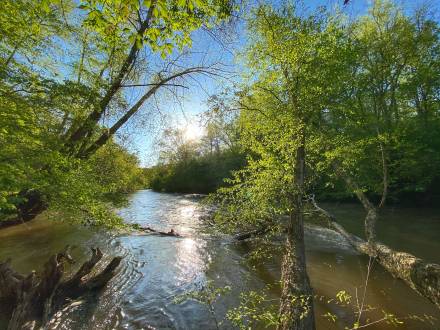
With only Class I-I+ rapids, this reach perhaps stretches the definition of "whitewater" despite a fairly rapid flow. But with agricultural or wooded scenery, minimal residential or road intrusion, a quiet, rural atmosphere and year-round availability, it is an excellent respite from the challenges of steeper rivers or the cold swims of winter. The reach is really two sections, an upper section from Highway 136 to Highway 9 and a lower section from Highway 9 to Kelly Bridge Road.
The 9.1-mile upper section from Highway 136 to Highway 9 snakes through a broad, flat plain consisting mostly of farms: with traffic noise mostly absent except for the highway crossings, boaters often hear the mooing of cattle. Residential development is still minimal right along the river, so the scenery remains agricultural. Though the traffic can only rarely be seen or heard, two roads parallel the Etowah on river right, Etowah River Road for the 4 miles from Highway 136 to Highway 53, and Thompson Road for the 2.6 miles from Highway 53 to Highway 9.
While the section is generally described as "Highway 136 to Highway 9," it may actually be preferable to take out at the Hugh Stowers Road bridge (about 1.8 miles upriver of Highway 9) or at one of the accesses in the Dawson Forest WMA. The hill down to the water at Highway 136 is steep, as is the hill up from the water at Highway 9: traffic is fast and somewhat dangerous at both bridges and parking is limited at the Highway 9 bridge. Directions to the alternate accesses are below.
The 9.1-mile lower section from Highway 9 to Kelly Bridge Road is even more beautiful. Most of the lower section is within the Dawson Forest Wildlife Management Area (WMA), eliminating the usual residential development. The WMA includes several vehicle roads, but they are generally well removed from the river and the traffic usually seen while paddling consists of occasional hikers, bikers, and horses. Deadfalls are common on the narrow river, but most can be easily avoided: There are a couple of bank-to-bank logs that may require getting out of the boat at low water levels.
In addition to the put-in at Highway 9 (or about 1.8 miles further upstream at Hugh Stowers Road), there are four access points within the WMA: three are reached by entering the WMA from Highway 9 and the other by entering from Highway 53. Once past these three locations, there is no other access for put-in or take-out until Kelly Bridge Road.
NOTE: the WMA is closed for maintenance from mid-May to June 1 each year. During this period, use of the river is permitted, but the gates are closed, preventing road access within the WMA.
Directions:
To reach the put-in at Highway 136, take Highway 136 west from Highway 400 or east from Highway 9 to the bridge. There is space along Highway 136 to park at any of the four corners, but the designated parking area is about 100 yards west of the bridge on the north side of Highway 136. Beware of fast moving traffic, especially coming around the curve just west of the bridge.
The Highway 53 bridge over the Etowah is not recommended as a put-in/take-out. The traffic is heavy and fast moving and the roadside parking is minimal, not particularly safe, and discouraged by local authorities. If you must access the river at the Highway 53 bridge, the least dangerous alternative is the south (downstream, river left) corner of the bridge, where the double traffic lane starts.
The alternative to access from Highway 53 or Highway 9 is the bridge on Hugh Stowers Road, about 2.7 miles downstream of Highway 53 and 1.8 miles upstream of Highway 9. To reach Hugh Stowers Road from the Highway 53 bridge, go northwest (toward Dawsonville) on Highway 53 for 0.75 mile, turn left on Thompson Road, follow Thompson Road for 1.1 miles to the 4-way stop and turn left onto Hugh Stowers Road. To reach Hugh Stowers Road from the Highway 9 bridge, go north 0.8 mile, turn right on Thompson Road, follow Thompson Road for 1.5 miles to the 4-way stop and turn right onto Hugh Stowers Road. Once on Hugh Stowers Road, go 0.8 mile to the bridge. To reach Hugh Stowers Road from Dawson Forest Road, turn north onto Grizzle Road at Black's Mill Elementary School and keep going straight when Grizzle Road turns to the right; the bridge is 1.7 miles from Dawson Forest Road. Access is available under either end of the bridge, but the north (river right) end is easier. Parking is roadside, but do not block the pasture access road at the northeast corner of the bridge.
To reach the Highway 9 bridge, take Dawson Forest Road west from Highway 400 (the intersection is at the light just south of the outlet mall and just north of Outside World) for 4.1 miles. Turn right onto Highway 9 and go 0.5 mile to the bridge (just past Riverview Middle School on the left). Minimal off-road parking is available at the southeast corner of the bridge, but stay on the right-of-way and off the private property just upstream. Being careful of the rocks, go down the hill at the parking area, cross under the bridge just above the concrete support and put in at the southeast corner of the bridge. (When you pause to rest, look across to the river right bank just downstream of the bridge and think how great it'll be when the canoe launch is there.)
About a mile below Highway 9, the Etowah enters the Dawson Forest WMA. There are four accesses to the river within the WMA, three reached from Highway 9 and one from Highway 53 west of Dawsonville. There is no fee for parking or river access in the WMA.From Highway 9, take Dawson Forest Road (found 0.5 mile south of the Highway 9 bridge) west. To reach the Shoal Creek Road access, turn right shortly before the entrance gate and go 0.4 mile to the bridge; the best access is at the southwest corner of the bridge, but be careful not to block the road or any gates when parking.
The main entry gate, 1.5 miles from Highway 9, is open except from mid-May to June 1, when the WMA is closed for maintenance. To reach the other two river accesses, continue on Dawson Forest Road for 2.6 miles, where the pavement will end; angle right onto unpaved Railroad Road. The Blue Trail Ford access is on the Blue Trail, a horse trail running left from Railroad Road about 0.2 mile after the end of the pavement; look for a pine-straw covered path and blue dots on the trees on the left. The put-in is easy and the carry is fairly flat and just a couple of hundred yards long, but does tend to be muddy and . . . . well, what you'd expect for a horse trail, so step carefully. Parking is limited, and you may need to go back and park at the clearing where the pavement ends. (The access from Highway 53, described below, reaches the river at the same point, but from the other side.)To reach the Railroad Road access, continue on Railroad Road another 1.6 miles until it is blocked by the concrete support for a long-gone bridge. (Railroad Road is also part of the WMA's Blue Trail, so drive slowly and watch carefully for hikers, bikers, and especially horses.) There are paths down to the river on both sides of the road; neither path is all that easy, but the path to the left as you face the bridge support is easier.
To reach the WMA access on the north (river right) side of Blue Trail Ford, take Sweetwater Church Road south from Highway 53: the intersection is 1.2 miles east of the Highway 53 bridge over Amicalola Creek, 2.25 miles west of the Highway 53/Highway 183 intersection. (Look for signs advertising "River Tubing - Kayaking" and "Sweetwater Baptist Church.") There is a second entrance to Sweetwater Church Road .3 miles further west; they soon merge. Once inside the WMA, where the pavement ends for the first time, Sweetwater Church Road becomes North Gate Road. To reach the river access, follow North Gate Road for 4.5 miles until it ends. (When you see the end of the second paved section coming, you'll need to angle left on the dirt road). Carry about 50 yards past the "road closed" gate to the right, then turn left on the Blue Trail and follow it about 30 yards to the river. The access and carry are fairly easy, but be prepared for mud and whatever else you'd expect to finD along a horse trail.
To reach the take-out at Kelly Bridge, turn west from Highway 400 on Jot-em-Down Road in extreme northern Forsyth County. Go 1 mile to the 4-way stop, then continue west on A.C. Smith Road for 2.2 miles to Highway 9. Turn right onto Highway 9, go 0.7 mile and turn left onto A.T. Moore Road (right across Highway 9 from the new CITGO station). In 0.7 mile, A.T. Moore Road will merge into Kelly Bridge Road. Stay on Kelly Bridge Road for 5.7 miles to the bridge. The take-out is at the northeast (upstream, river-right) corner of the bridge: the driveway is blocked by a gate that is closed but not locked; to keep this private take-out available, please pay the $2 per person parking fee, fill out the card and keep the gate closed except when you're actually driving through it. Stay away from the gate across the road, the one with the "trespassers will be shot, then prosecuted" sign.
To reach the take-out from Highway 53, turn south onto Cowart Road from Highway 53 1.5 miles west of the Amicalola Creek Bridge (5.25 miles west of the Highway 53/Highway 183 intersection). Take Cowart Road 2.5 miles to the 4-way stop at Kelly Bridge Road and turn left. Stay on Kelly Bridge Road 3.4 miles to the bridge: the driveway to the take-out will be on the left shortly before the bridge (look for the gate on the left with signs on it - stay away from the gate on the right).
Highway 136 Section